The Once (Very) Wetlands of Coed Y Brenin
Actions and Inactions in Bogland Restoration!
As usual I'm talking specifically here of Mynydd Penrhos, known as the Core Block of Coed Y Brenin, planted first and most varied in the original choice of species. Its the area I know best, having wandered all its tracks and footpaths for the last 37 years and ventured “off piste” so to speak on many an occasion, finding a wealth of surprises and wonders.
Mynydd Penrhos and the surrounding hills can be very wet, as the name suggests. The name translates as something like Mountain of the Top (pen) of the Marshland or Moorland (rhos). With an annual average rainfall of between 2 and 3 metres and thin soils over bedrock, it favoured the development of wet moor, damp meadows, marshes and peat bogs of varying size, with some open water in places (Bryn Merllyn) and extensive issues, where water percolating down through the soil meets an impermeable layer and reappears at the surface, usually on slopes.
Bryn Merllyn in a wet phase. You can find the Substack piece I wrote about it here.
There are surprisingly few streams draining what is a considerable upthrust of rock. A handful exit on the western side in extremely steep descents that vary from dribbles in dry conditions to torrents in wet. The Mynydd itself actually consists of two ridges, rising to form a watershed at the north end and opening to the south but only draining a relatively small valley between them, again giving rise to a mere dribble when dry and more of a babbling brook when it's wet.
The northern end of the Mynydd is drained by a single stream, beginning at Llyn Garnett Uchaf (more of which later) and running first east through a fairly extensive bog before curving round to the south, picking up another tributary, passing through our own holding and finally descending rapidly down the end of its little hanging valley, into the Afon Wen. Its this stream which drains areas that were formerly peat bogs.
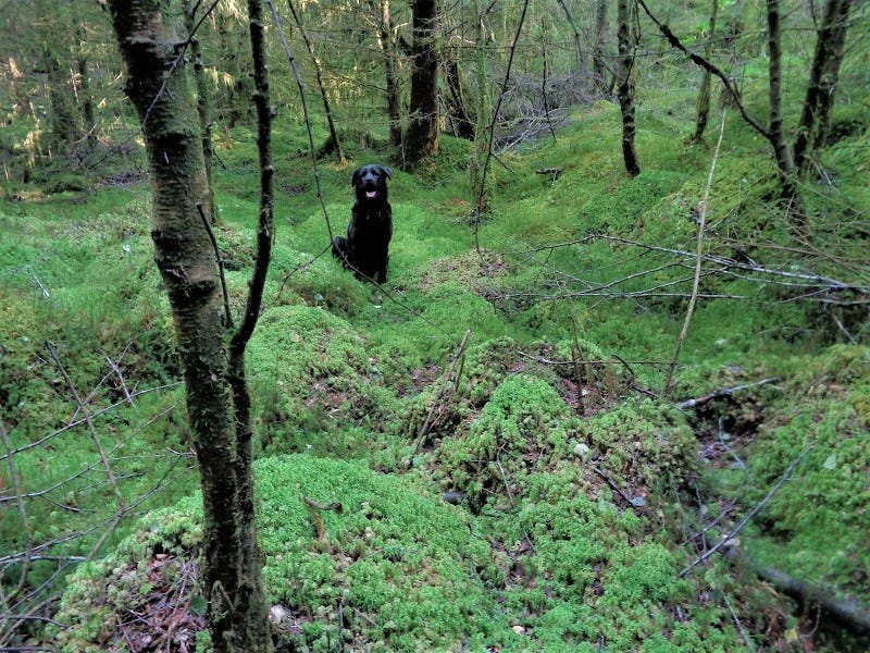
Remnants of bogs can be found on almost any sunken area, as well as in the bottoms of the many small valleys and the dips in the shelves that jut out from the slope. Together with the many issues, these wet soils favour the the growth of rushes and mosses, including sphagnum. Wandering “off piste” I have found expanses of sphagnum moss on quite severe slopes, surviving apparently happily, under the trees that have not grown very well due being planted in a bog... Able to hold from 8 to 20 times its own weight in water (depending upon which source you consult) these sphagnum beds can slow the flow of water considerably, hang onto it and release it slowly.
above: mostly sphagnum moss under struggling conifers and sparse birch below an issue running down towards the foreground, so damp to wet for much of the year.
Peat formation is very clearly linked to sphagnum moss in mires, raised bogs and blanket bogs. Indeed, as I've mentioned before, the source of the Afon Mawddach is some 9,000 acres or so of bog in the uplands, a vast plateau land that's acts like an invisible lake, storing huge quantities of water.
With the increased likelihood of flooding due to high rainfall events its no wonder then that there is so much concern about preserving and re-establishing wet lands and peatbogs, particularly in the uplands. They have an enormous role to play in the storage and cleaning of water, acting as buffers to reduce the speed of run off and hence reducing the risk of flooding. One of the reasons why in permaculture design, we will always try to store water as high as we can in any landscape.
It can be difficult to establish the original sizes of the peat bogs of Mynydd Penrhos, due to the often extensive drainage ditches cut by the Forestry Commission prior to planting, the drying effect of sticking thousands of trees into them and the radical disturbances of machine clear-felling and extraction.
On Mynydd Penrhos there are several fairly obvious, larger natural depressions where peat has slowly formed since the last ice age. In the more recent past some of that peat (a very small proportion) was dug to heat the scattered dwellings of the subsistence farmers I have talked about before, the tyddynwyr, or smallholders. In some cases, such as on our own holding, depressions can be seen in the land suggesting where the main peat cutting beds were.
Other clues can be found in the neat, rectangular mounds of stones that mark a turbary or peat cutting area. I was familiar with what are called field clearance cairns which are simply piles of stones that have been cleared from the surface of the land when those early farmers began to make fields. Larger stones were used to make the walls that enclosed the field so usually the clearance cairns contain smaller stuff. The cairns tend to be round or roundish and today often have oak growing on them that date back to before the planting of Coed Y Brenin.
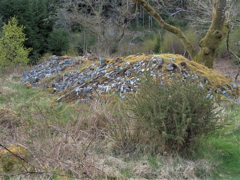
The neat, rectangular peat drying mounds are quite different though, measuring some 30 feet by 10, (say 10 by 3 metres) and sloping upwards towards the centre, like a low, peaked roof. When I first came across them, my imaginative, speculative self wondered whether their relatively precise forms were in fact some sort of ancient barrow, concealing graves of past heroes. However, in conversations with my good friend Andrew Wolf, an archaeologist, I was put on the right track.
above: a well preserved example of a substantial peat drying mound on the edge of a turbary with the long axis facing south.
Andrew explained that these rectangular piles were usually constructed of larger stones and were used in the first year of drying cut peat. They were built with the longer side facing the south, though depending upon the lay of the land, they may be angled a bit towards the east or the west to make best use of the morning or afternoon sun. the slices of peat were laid out on the sunward facing slope and left to dry for the first year. In the second year, the peat was moved to a barn for further drying before being burned in the third year. I've found several of these rectangular, peat drying mounds on the sides of depressions in the landscape which were most obviously peat bogs in the past.
Here on Mynydd Penrhos, prior to planting the conifers, deep drainage ditches were dug in the peat bogs, following the herring bone type pattern. When I first pushed my way through the trees in the 1980s, in one of the drained peat lands just above us, I walked a dry ditch that was some four feet wide (1.2 metres) and at the lower end so deep I couldn't see out of it. Other ditches from those early years are still visible, some seemingly incongruous, apparently going nowhere and draining nothing, on sloping sites and ridges which you would not associate with wetland.
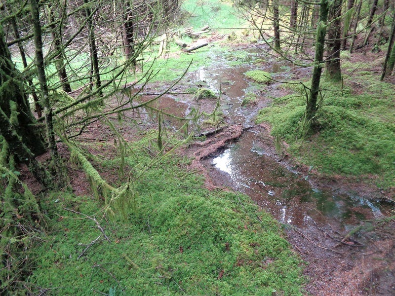
above: wet hollow on Mynydd Penrhos and likely peat bog in the past. Note the poorly grown conifers and extensive moss in the foreground. A harvester has cut an access track running from left mid-ground to centre background and beyond.
Following the appointment of Dr. Martin Garnett to the Forestry Commission as the Conservation Ranger (the first in Coed Y Brenin and in the UK, I think, and almost certainly the most highly qualified!), I had the chance to give some feedback on the opportunities presented by the clear felling of much of the southern end of Mynydd Penrhos, Bryn Coch and Bryn Merllyn, in the 1980s.
I'd had a good look at the topography of this newly exposed landscape, strewn as it was with waste wood and uprooted stumps after the clear fell. I could see tremendous opportunities for building more water storage into the landscape through the recreation of peatlands and bogs and the inclusion of ponds of varying sizes.
One particular site of perhaps half a dozen acres, had obviously been a bog because despite drainage ditches, it still was.1 The centre of the bog had remained completely open, as everything planted there had died.2 Towards the edges you could see the stunted bodies of trees in their rigid, close-planted geometry that had struggled on, managing a scant few feet in height before giving up and been left at the time of the clear felling as not worth bothering with. All the drainage seems to have done was favour Molinia grass over sphagnum moss.3
The Forestry Commission Conservation Ranger, Dr. Martin Garnett, (or Doc Martin as he was often known), had to work within the limitations of the Forestry Commission and budgets but was still able to organise the creation of a new pond and the safeguarding and improvement of a more substantial body of wetland, towards the very top of the watershed, the best place to start storing water!
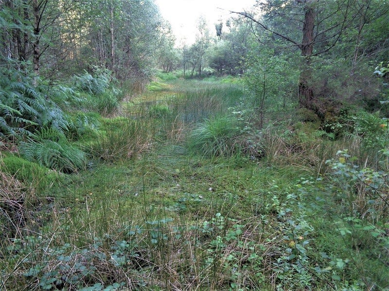
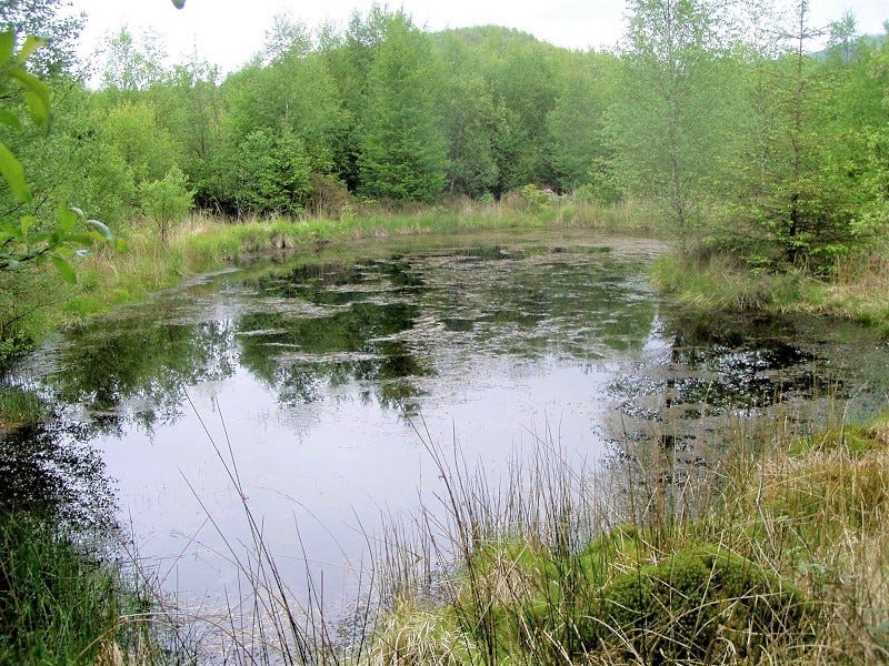
above: just a small part of Llyn Garnett Uchaf, a wonderful mosaic of open water, sphagnum, bog, rushes, sedge, mollinia preserved and extended by simply raising the outflow.
This latter project was a great minimum effort maximum effect operation. The original outflow of this bog had been considerably altered by a Forestry Commission track which had meant the normal issue had to be confined to a pipe which spilled down into a gutter under the track. By simply arranging for the raising of the outflow pipe, Doc Martin increased the area of the bog by several acres. Its now an amazing patchwork of open water, rushes, mosses and the like.
Llyn Garnett Isaf: an open water pool dug into the water table hence always full. Home to dragonflies, amongst many other life forms. Another tribute to Doc Martin. The original bog extended for a considerable distance below but is now being drained by birch and willow.
Having carried out my own wet land re-creation project at home, using fascine causeways4 I was keen to try something similar on a larger scale and our watershed seemed like an ideal location. I knew it very well, probably better that most, I'd identified the old peatlands and could see how causeways would work well.
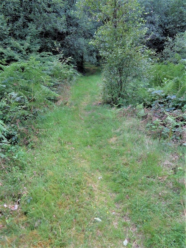
One old peat bog in particular was ripe for reinstating. The trees currently growing on it could be cut and bundled for fascines so all the materials are already there. A public footpath runs across the bog remnant with a little bridge over the main drainage ditch- simple to block and the footpath becomes the first causeway, with say 6 inch (150mm) pipes replacing a fascine every 10 feet (3 metres) or so and the top levelled with soil or gravel from the very nearby quarry or wood chip (plenty of wood lying nearby for chip). The pipes would allow overflow in times of high rainfall, spread along the entire length of the causeway and out-flowing into vegetation rather than ditches and consequently slowed down and infiltrated back into the new bog.
above: footpath over drained bog. The birch tree on the right marks where the original drainage ditch passes under the path at a depth of about 1.5 metres.
No other dwellings would be effected and all the water drains out through our land and under our track, so it would be relatively easy to monitor flow rates and hence assess success or otherwise of our actions, something which I think is essential- if we don’t measure the consequences of our actions, how do we know if they are really effective. I'd also got Graham Hall, our local sane scientist interested5 and I’d looked at possible funding opportunities for a pilot scheme.
In 2022, Natural Resources Wales (NRW) held an open day event in Neuadd Y Pentref Ganllwyd (Ganllwyd Village Hall) and various representatives of the organisation were on hand to explain a revised strategy (yet another one, with yet more colourful maps) and answer questions. This seemed like the ideal opportunity to broach the idea for restoring some of the peatlands on Mynydd Penrhos.
I spoke first to the NRW Community Liason Officer (a very friendly and supportive individual) and she pointed me to someone (a bloke who shall remain nameless) who seemed like an ideal candidate as he had already been involved in some peatland restoration with NRW. I went over and explained what I saw as the opportunities that Coed Y Brenin offered. Wow, talk about not interested! He couldn't have been more uninterested if he'd tried! Oh, he was trying...
Its a crying shame really because the peat is still there but its drying out and so absorbs less and less water and breaks down, releasing all that stored carbon back into the atmosphere as carbon dioxide.
Perhaps an opportunity will arise at some point and here's hoping. Maybe I should just get more uppity about it. Meanwhile, someone quite close to me practices a form of guerilla wetland restoration and encourages material (logs, boulders etc.). to take up residence in the ditches.
Thanks for reading. You can voice your suggestions, corrections, additions, criticisms or any other -tions or-isms you like in the comment box below. Next its back to Konsk, a fictional account of hoe folk might experience and deal with the simultanoeus descent, transition and collapse of industrial techno-consumer society or Imperial Modernity, as Jem Bendall puts it in his new book, Breaking Together which he has made available for free here. Doubtless I will refer to it again. Take care all. Hwyl! Chris
It is thought that digging a ditch in a bog will only drain up to a metre on either side of the ditch, hence the need for multiple ditches at two metre spacing, arrayed in the herring bone pattern. A lot of time and energy has gone into this practice in the past.
I wonder why some of Coed Y Brenin was ever planted. There must have been some sort of Kudos attached to the acreage planted every year that overuled any practical consideration. Not only were bogs and wetlands drained and planted up but ridiculously steep slopes that became dangerous liabilites as the trees matured and blew down and have been hugely expensive to safely fell. Other areas that had absolutely no access to get the timber out were stuffed full of conifers without a thought to the future. The District Managers must have been watching those acreage figures clocking up and feeling immensly pleased with themselves, knowing they would have retired long before anything had to be done about it
The loss of the tyddynwyr should also be taken into account. They would certainly have let their cattle graze on the bogs. Being wet the bogs tend to be warmer than the drier land in winter and hence provide a late autumn and early spring bite for cattle. This is a practice that has now been reinstated in several areas in Cymru and beyond.
You can find details of the fascine causeway project at Tir Penrhos Isaf and other strategies for water management here.
Incidentally, I sent links to this design to all the major conservation bodies at the time and didn't get a reply from any of them! Some time later I heard about a large scale project on Pumlumon, re-instating upland bog by using fascines to block the drainage ditches. When I checked this out they'd put the fascines in along the ditch, and all the way up the ditch, using, of all things, mini-diggers! What a waste of time and energy. By putting in fascine causeways across the ditch in several places, (top, middle and bottom, for example) you slow the flow of water without needing to fill in the entire ditch which fills itself in through the sides slumping and through deposition of material due to the slower flow of water. The causeway allows access across the bog, something which is generally more or less impossible and as the sphagnum recovers, an additional layer of fascines can be added to further increase the storage capacity.
For his Phd, Graham carried out a remarkable examination of forest hydrology with Coed Y Brenin as his subject area and basing much of his equipment and experiments at our place as well as throughout the forest. I will inevitably write about this in a later issue of The Real Coed Y Brenin, as it contains some really useful information (like the fact that rain is more likely and heavier over the forest than over agricutlural land) and significant clues towards landscape management. Among other things, some of the results showed quite clearly that our own place was the wettest place in Coed Y Brenin in the summer….


Thanks for the namecheck, Chris. That conversation must have been a long time ago! Great stuff, I read 'em all. Atb, Andrew.