


After the Ice the Trees.
And two rival theories of Forest Development.

But are they in fact rivals, or perhaps both occurred at the same trime in many different locations?
In the previous chapters of The Real Coed Y Brenin, I looked at the very early, geological history of the site and in particular the great volcano, Rhinog Fawr and how it shaped the structure of the landscape. I then skipped a few hundred million years to the Ice Ages and especially the last one, that ground up rock in its glacial progress and deposited sands, gravels, rocks, stones and boulders wherever the topology of the landscape and the flow of water directed. Here I take up the story with the return of vegetation to land that had been covered by glaciers, ice sheets or permanent snow for millennia.
above: ffridd (see below) or is it something like the original ecology of Britain?
After the Ice.
As the last Ice Age ground to a close some 12,000 or so years ago, the ice and snow gradually began to melt and Britain, an island again, starts to warm up. The climate didn't simply recover to its present level, but underwent a series of fluctuations, at times becoming warmer and drier than at present, and then again approaching glacial conditions1.
Here in Cymru, after tens of thousands of years under glaciers and ice sheets, the melt revealed a landscape rich in minerals but lacking organic material. Plant life returns to this once frozen land, moving through first lichens and mosses into arctic willow and other cold tolerant species like birch and silver fir, to shrubs, bushes and the trees common in the last century, such as oak, ash, elm, lime, hazel and the like. These ecosystems, dominated by trees, were seen as a climax and end point to development and occurred alongside soil building and increased water storage.
Until relatively recently (2000), this theory of forest development, from next to nothing to climax forest was generally accepted and supported the idea of Britain being covered for many thousands of years by the Wildwood. The Wildwood was thought of as a dark and forbidding place beneath the continuous canopy, only the occasional clearing where a forest giant had fallen providing some brief opening to the sky, soon to be filled as young saplings race towards the light. The wildwood made much of the land impassable and dangerous, the haunt of wild beasts like wolves and bears.
above: a closed canopy, here on Argel after the cull of the deer removed the grazing pressure on trees.
However, even before the turn of this millennium these view was being challenged. As Britain warmed up it moved from an arctic climate, through sub-arctic, a boreal period and on into the present temperate climate (how long will this last, I wonder?). Through observations of similar climatic zones, we find that tundra is home to huge numbers of large herbivores such as Reindeer and Caribou, who migrate in sometimes vast numbers and exert a tremendous grazing pressure on landscapes at particular times of the year.
Given that Britain supported several different species of deer, aurochs (huge wild cattle) as well as wild boar and beavers, it seems likely that they would have some not insignificant influence on the development of forest systems.
It was also clear that the spread of forest slowed radically in the uplands when the climate became much wetter at times which favouring peat formation in blanket bogs over trees. There is also some argument that the summit climate of British mountains can approach subarctic conditions and so doesn't favour tree growth2.
More recently, parts of the south east of Britain seemed to have been clear of trees for several thousand years. Julius Caesar, for example, on his brief excursions to Britain relates in his Bello Gallicum (the Gallic War) how the Britons he encountered there used chariots extensively and effectively; for a chariot to be usable at all, let alone in warfare, a relatively smooth, open landscape is required.
I became more doubtful of the standard model following my own observations of re-vegetation on the experimental site here at Penrhos that I called Argel3.
Here, with a large, feral population of fallow deer eating out all the tasty young saplings, a much more complex and interesting environment appeared. The pressure of the grazing and browsing by the deer favoured the growth of spiky plants, notably gorse, which sheltered young trees, including birch, willow, oak and hazel and meant that open areas between gorse clumps were maintained as grass pathways and small clearings, preserving the previous sun loving, pasture species. This led to a complex topology and a patchwork environment presenting many niche spaces for other species.
It was only after the very large cull of the deer in the early 1990's4 that tree growth proceeded as described in the theory and a closed tree canopy rapidly developed. This in turn led to the loss of the sun-loving pasture species and an overall reduction in species diversity.
above: Argel after the cull. Note the density of tree regeneration, hazel and birch, after the deer cull; the canopy rapidly closed and shaded out the sun loving plants.
So where did this theory of climax forest come from?
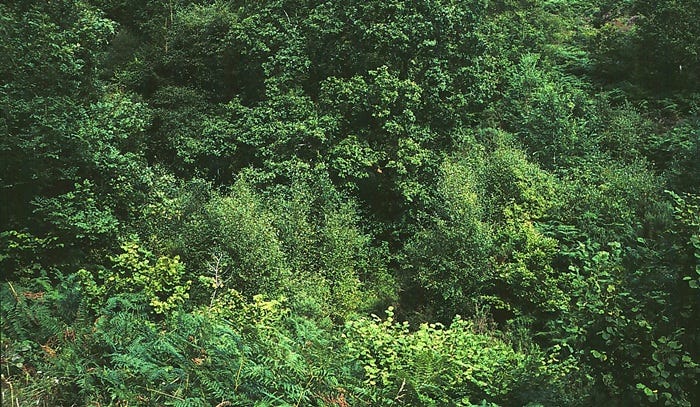
The theories of forest origins were largely based on observation of abandoned farmland on mainland Europe during the twentieth century. In these cases, re-vegetation occurred without pressures from large herbivores. The result is a simple progression from grassland through taller herbs and shrubs and on into complete tree-cover which will assume the appearance of a climax ecology. These observations became the basis for the general theory.
My own thoughts of the limiting effect on tree development by the grazing pressure of large herbivores were confirmed in much greater depth and detail by the work of F W M Vera in his excellent book, Grazing Ecology and Forest History5
Vera describes how the pressure of mixed species of large, grazing and browsing herbivores favours the growth of thorny plants like gorse and black and white thorns which then provide protection for trees. His description of blackthorn is particularly striking as the tree grows outward annually through suckers, forming dense thickets. Jays tend to stash (plant) acorns on the edges of blackthorn thickets, many of which go on to germinate and grow and are then engulfed by the ever expanding thorn.
These trees, protected from grazing animals by the thorns, grow on and upwards to shade out the blackthorn, creating oak groves in grasses surrounded by the blackthorn boundary which continues to expand, engulfing and protecting yet more trees. There is a good argument here that these eventually huge blackthorn thickets are the basis for the hunting parks of the aristocracy.
Vera also talks about steep sided slopes being less accessible to the larger herbivores, thus favouring the growth of trees. This is something that is confirmed in the Welsh language and culture; as I have mentioned before. An allt in Cymraeg originally referred to a steep sided, wooded hillside and the term abounds around here, such as Allt Fridd Goch, Allt Moel Dolfrwynog, Allt Pen Y Bryn and the like.
above: Allt Mynydd Penrhos. Here the allt was not cleared and planted by the early Forestry Commission (unlike some ridiculously steep slopes) so the original species, here oak, have grown on. Allt, originally a wooded slope, would have been managed by tyddynwyr for small scale coppice such as sessile oak and hazel. Here, the formerly coppiced oaks have been ignored for a century and grown away freely, vying for space and light with each other, producing many long, thin, winding branches.
So rather than climax forest cover, Vera argues for a much more complex landscape of groves, copses, thickets interspaced with open, grazed areas, parts turned over by wild boar, allowing annual species to flourish in the bare earth, no doubt areas laced with the pools and channels of beavers and areas of denser forest along steeper valley sides. Hence a very rich and varied, dynamic landscape, a tapestry or patchwork of ecological niches.
This landscape that Vera describes is very like the ffriddoedd (plural of ffridd) of Cymru, and most particularly of western Meirionydd. Here, ffridd appears between the fields of a farm and the mountain wall. It is an in-between zone, an edge zone, edges being most significant in permaculture design; edges span two zones, such as field and forest and hence incorporate species from both, so being more diverse than either zone alone.
Ffridd.
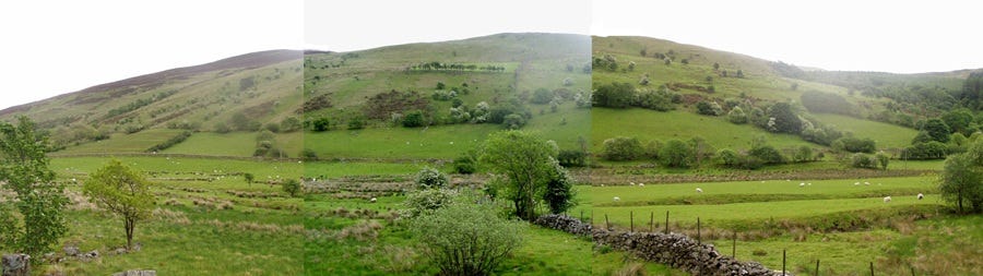
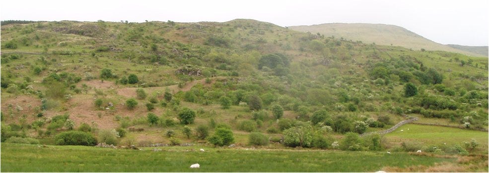
above: a composite picture of a fridd remnant running across the side of the hill, with just a scatter of trees remaining, thorn (flowering white) and some gorse (yellow/brown). The land is now being grazed exclusively by sheep with the fridd incorporated into the mountain grazing. Interestingly, the mountain wall includes a clawdd or earth bank, indicating a very old land division. The lower, fridd wall is more obvious where the trees stop and the fields begin.
Carwyn Graves in his excellent recent book, Tir6, gives a detailed description of ffridd and you can find my own work on ffridd here[. Interestingly ffridd was not originally a Cymric term but is borrowed back from the French before becoming thoroughly part of the tradition and culture of Cymru. There is no direct English translation and suggestions such as Tree Pasture or Field Trees come nowhere near to it. I have used the term Celtic or Cymric Agroforestry at times but again this is insufficient. I have also described it as permaculture design's Zone 4, Fuel and Forage Forest which is closer to the actuality but still does not really convey the species rich beauty of it.
Imagine a complex mix of trees, shrubs, herbs, grasses of varying ages, sizes and heights with a highly varied topography, a complex mosaic of species which was dynamically managed by the tyddynwyr (smallholders) through the grazing of limited numbers of a variety of animals (cattle, sheep, horses) at certain times of the year. If trees showed signs of becoming too dominant, the tyddynwyr would harvest some for building materials and fuel and perhaps leave some of the livestock on for longer. If the pasture within the ffridd looked like it was spreading too much, then they would reduce the stocking rate or move animals off earlier.
Ffridd was then very much a conscious management of a landscape through livestock which resulted in something which sounds very much like the original landscape of Britain that had developed in the presence of large herbivores after the ice. So if we imagine that something like ffridd was the more general appearance of the British landscape several thousand years ago, then we could consider that the ffridd remnants we still have in Cymru today, especially in western Meirionydd, might represent survivals of this original landscape.
Vera's theory of grassland ecology and forest development is still contested (quite vociferously by some!). In particular, oak is a problem as the pollen record shows it grew in proliferation with other trees, suggesting a climax forest, yet it does not regenerate well in woodland unless it has a good amount of light, suggesting a more open landscape.
Whatever, as is often the case, I think its more likely that examples of both theories of forest development would have been found in Britain. So after the ice age, I can imagine the re-vegetation of Britain including large numbers of herbivores and their predators to create a highly mixed environment that no doubt did also include very large, dense stands of climax forest, possibly where humans had hunted out the larger animals, as happened on other continents and at other times. The landscape would also include often extensive open, grazed areas with more scattered trees and shrubs growing out of the protective spikes of black and white thorns and gorse with steeper hillsides favouring denser tree cover.
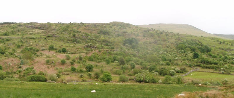
above: a closer view of the first photograph, showing denser clusters of trees with a closed canopy, scatters and clumps of trees and bushes, with thorns displaying white blossom and many open areas, now, in the absence of heavy browsers (cattle and horses) are giving way to bracken. Is this something like the early landscape of Cymru looked?
As human occupation of the island increased, forest development and tree cover was further modified (steered) by our activity. Considerable quantities of coppice hazel were required to construct roundhouses, hurdles, trackways and the like. There is a suggestion that a sudden decline in the number of elm, evident from the pollen record, was the result of coppicing branches for leaf fodder for livestock and hunting would gradually reduce the numbers of the larger herbivores, allowing for more tree regeneration.
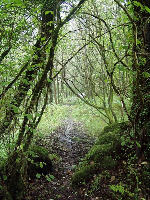
above: looking into the closing canopy at Argel, after the cull. Note the use of sticks and branches through the first wet bit- a very ancient practice.
But the Wildwood is an idea that is rooted as much in legend and imagination as in reality and over the last few decades there has been much argument and heated debate surrounding alternative views of forest development in Britain. Further, Vera's book has provoked considerable interest in Rewilding, usually to the exclusion of humans and without consultation of the original occupants of the landscape, notably the Summit to Sea Rewilding Project, imposed on the people and landscape of Pembrokeshire and then withdrawn due to the considerable local resistance.
From a permaculture design perspective, the complex, mosaic landscape suggested by Vera and modelled by the friddoedd of the Cymric tyddynwyr, presents an enormously varied and dynamic landscape, rich in species diversity and hence offering harvests of many types; in short, capable of providing us with all our basic needs.
Thanks for reading and a very warm welcome to new subscribers. Not sure what will appear next yet… The Real Coed Y Brenin moves on to the the appearance of Penrhos Forest, mentioned in the Norman forest lists (very organised, those Normans), that covered Mynydd Penrhos and the surroundings for centuries before it was felled illegally by the local gentry to fuel an iron smelting venture- capitalism, eh? Long roots. Also, we’ve got further episodes of Heads At The Little Big Farm, a second strand from the meta-pata-fiction Konsk. And no doubt something else will catch my consciousness unawares and demand attention, so who knows? Till we do, take care. Hwyl! Chris.
“It is found that the dry, mainly cool Boreal period extended from about 6500 to 5200 B.C., the moist warm Atlantic period from 5200 to 3000 B.c., the dry warm sub-Boreal from 3000 to 850 B.C., and the wet cool sub-Atlantic from 850 B.C., to about 300 A.D. “
The Climate of Prehistoric Britain. Published online by Cambridge University Press: 02 January 2015
It is worth pointing out though that trees of various species have been found at very high altitudes, though admittedly they are generally stunted or dwarfed examples of their species. As examples, a Scots pine was found at 1,160m (3,806ft) on Cairn Lochan, Cairngorms and a Rowan at 1,130m (3,707ft) on Sgurr nan Ceathreamhnan, Glen Affric. This BBC article gives some other record breaking altitudes for trees in Briatin..
See my web site for a detailed description of Argel or read one here on Substack.
When the Forestry Commission, under pressure from local landowners, eventually paid for shooters to come in and cull the herd, reputedly over 2000 animals were shot in the first year, an indication of the size of this invisible, organic herd that no one fed or managed in any way. Unfortunately, not being local and with no interest in the herd, rather than killing injured, wounded, old and weak, the shooters shot whatever they saw, including the oldest and wisest does and the best bucks.
F W M Vera Grazing Ecology and Forest History CABI Publishing 2000 ISBN: 9780851994420
Sadly very expensive so get your library to find one.
Carwyn Graves, Tir: The Story of the Welsh Landscape March 2024
very interesting. Thanks for including a link for your article about ffridd. I was looking for it a while back, because I thought my daughter might be interested but couldn't find it anywhere at the time. She's doing a PhD on the ruined cottages that scatter the hills above us and over into the Eigiau and Cowlyd valleys. Many of them, but not all, would have been mining settlements. I'm not sure if it would be relevant or not but much of what she's trying to do is to piece together the lives of the people who lived there and many of the wills include reference to cattle and other livestock