Here in Cymru I used to think about western fronts coming in over the sea with rain descending from dark clouds but its not always quite like that. Warm air is able to hold more moisture than cold air. Warm, moist air blows in from the west. Sometimes it is so warm and carrying so much moisture that some of the moisture is visible as clouds and sometimes rain does indeed descend from such clouds.
More often though, as the warm, moist air moves over the land and rises up over hills, it cools. The moisture in the air nucleates around dust particles and bacteria and form rain drops which then begin to fall under the influence of gravity; it starts to rain. (I'm not really trying to teach you how to suck eggs, just establishing the scene. Now I've used that idiom, I realise that subscribers in other countries who may not share the idiom about teaching our grandmothers to suck eggs, will probably not have any idea what I'm talking about- sorry).
Trees and other plants draw water up from their roots and express it from stoma on their leaves, allowing the trees to lift water, against the force of gravity, tens of metres above the surface of the earth, a phenomena that is still not fully understood. Like our blood supply, the water is a vehicle for transporting nutrients up and through plant bodies and down again, as it happens. The process by which the water is expressed from the leaves is known as transpiration.
Apart from the trees transpiring water vapour, the other factor that can be very significant for air moisture content or humidity is evaporation. During a rainfall event the leaves (I'm including conifer needles as leaves here, which they are) of the trees become wetted. The surface area of a tree's leaves is enormous1 and can hold considerable amounts of water.
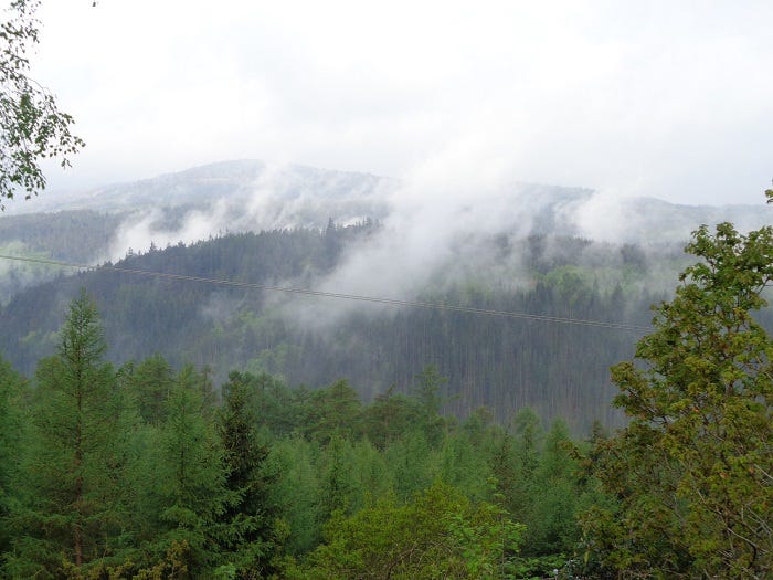
As all this water evaporates it adds to the moisture content of the air in and above the forest. During some rain events this can be clearly seen as mist rising up off the trees. The combination of evaporation and transpiration, usually referred to as evapotranspiration results in increased humidity in and above the forest.
above: evapotranspiration visible as mist rising up from trees shortly after and sometimes during a rain event.
In a forest system, such as here in Coed Y Brenin, some 19,000 acres (7689 hectares) of trees are actively transpiring during the day, releasing vast amounts of water back into the atmosphere. This means that the air in, around and above the forest contains more water than over surrounding land, whether agricultural or say moorland. When warm, moist air blowing in from the west meets already moist air rising up from the forest, the combined amount of moisture can reach a maximum, a saturation point and it begins to rain. So rain is more likely to begin over forest systems, something that is even more apparent in tropical rainforest, hence the name.
This phenomena of forests, sometimes called cloud catching, was demonstrated by work carried out by Dr. Graham Hall, our Dolgellau based, sane scientist. Graham, of Bangor university and Coleg Meirion Dwyfor, Dolgellau, conducted a number of research projects related to our area and in particular, a detailed study on the forest hydrology of Coed Y Brenin2.
Hydrology is the scientific study of the properties, distribution, and effects of water on the earth's surface, in the soil and underlying rocks, and in the atmosphere. Forest Hydrology relates the same to forest systems in general and with Graham's work, specifically Coed Y Brenin. Its a very thorough and highly detailed, fascinating study and forms the basis of many of the key points here.
As part of the study, Graham installed multiple rain gauges, thermometers and humidity sensors throughout Coed Y Brenin and beyond, including at our own site where he also conducted a number of other experiments, more of which later. The gauges measured and logged data at three minute intervals, allowing very precise monitoring of rainfall events. Every few weeks he wandered around the forest (good work if you can get it!) to download the accumulated data from each sensor onto a laptop. He was then able to use software to produce sophisticated, animated maps of rainfall events as they developed in the forest and beyond.
A number of interesting things arose from this mapping. For example, we learned that our own site, on Mynydd Penrhos, in the heart of the oldest part of Coed Y Brenin (known as the Core Block), receives up to 40% more rain than a site in Ganllwyd, only about a kilometre away as the crow flies. According to Graham, taken along with other, similar readings, this demonstrated, for the first time in Britain, cloud catching by temperate forests. That is, it is more likely to rain over forests than open land and the rain is likely to be heavier.
Another interesting (perhaps in the Chinese sense) finding was that our site was the wettest place in Coed Y Brenin during the summer... The epicentre3 drifts a bit further north and west for the winter so we can at least be thankful for that.
Graham's animations of rainfall events make interesting viewing. As I indicated at the start, the rain doesn't necessarily sweep in from the west, rather it can begin to rain over the forest first (usually over us...) and then the area of rainfall expands outwards and westwards. Sometimes the rainfall will begin in various places over the forest at more or less the same time, either going on to expand over larger areas or sometimes just dying out.
Here in Cymru, that combination of warm, westerly fronts already high in moisture, plus forests of native species, led to the development of what Dr. Martin Garnett called temperate rainforest back in the 1980s. More often these days the term used is Celtic Rainforest, which is nice in a poetic sort of way but not as useful or accurate as Doc. Martin's. Whatever, one consequence of this was the development of forests supporting a very wide diversity of lichens, liverworts, mosses and ferns, something that makes them fairly unique in Europe.
above: the high humidity of Coed Y Brenin is clearly visible in the abundance of mosses.
Of course, Coed Y Brenin “Forest” began in the 1920s as a plantation made up of pure stands of various exotic (that is, non-native) tree species, providing only very limited niche space for native plants. This is especially noticeable with lichens; whereas native trees here, such as oak or blackthorn can be more or less covered with lichens, they are generally sparse or absent on conifers. Under dense stands of conifers or ones that cast considerable shade, such as western hemlock, there is often insufficient light even for mosses to grow.
Graham's study looked at the source of the Afon Mawddach, (the river Mawddach), Waen y Griafolen, (meaning something like Wet Land of the Mountain Ash), a blanket bog covering a plateau basin of approximately 6 km2 in the Arennig mountains with an average depth of peat of 2.3 metres. The important point here is that despite the depth of old peat, (9,000 years or so!), it is the much shallower, living layer of sphagnum moss that provides most of the temporary storage of water, buffering the effects of high rainfall events or flash flooding.
With the prospect of less rainfall in the spring and early summer, keeping that living layer wet will be crucial and Graham talks about the possibility of putting weirs into the outlets as a means of slowing down the flow of water. I'd always thought of my fascine causeway design as applicable to both bog creation and regeneration, as rather than just blocking drainage ditches it provides the opportunity to gradually raise the level of water over substantial areas, while growing the materials (willow) to create more causeways. It also provides a dry access to bogs or wet land to allow observation and study4.
From this vast bog the Mawddach and her tributaries descend through steep, narrow, boulder filled valleys with many a waterfall. When in flood these rivers carry considerable amounts of stone downstream and Graham describes them as “gravel trains”. During our Great Flood of 2001, Merfyn, who lived in Ganllwyd with a garden backing onto the river, told me how he put a cup of tea on his table and watched ripple patterns appear; he could hear a continuous dull rumbling and feel vibrations through the floor as boulders were tumbled downstream. This flash flood saw a peak rainfall of 90mmof rain in a three and a half hour period5.
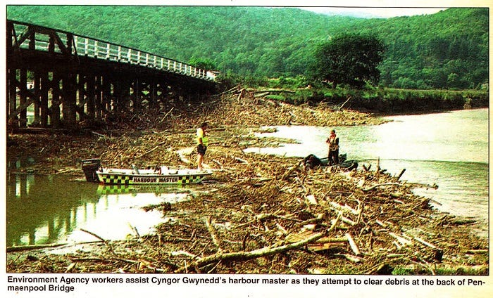
The effects were considerable, made much worse by the Forestry Commission, Cymru, having left stacks of timber on the river banks. This wood was swept away as the rivers burst their banks and carried downstream to a road or footbridge where it formed temporary dams until the accumulated weight and force of water was sufficient to sweep the bridges away sending a surge down to the next bridge where the process was repeated.
above: after the Great Flood of 2001. Note the debris piled up against abridge pillar- a packed mass of tree trunks, logs, roots, boulders, stones, gravel and soil. All the surviving trees on the riparian zones had similar masses of debris impacted on them. The river here rose some 24 feet or 7 metres and you may be able to make out bent railings on the bridge from the impact of debris carried down on the flood.
In all twelve footbridges were destroyed and three road bridges required major repairs and in one case, complete rebuilding. The height of the Mawddach was measured at 24 feet (about 7 metres) above its normal level and the banks of the rivers were swept clear of all vegetation, including hundreds of trees and stripped of soil, leaving bedrock that looked like it had been sandblasted clean.
above: after the Great Flood- many hundreds of tons of timber swept down the Mawddach accumulated at the bridge at Penmaenpool. Picture courtesy of the Cambrian News.
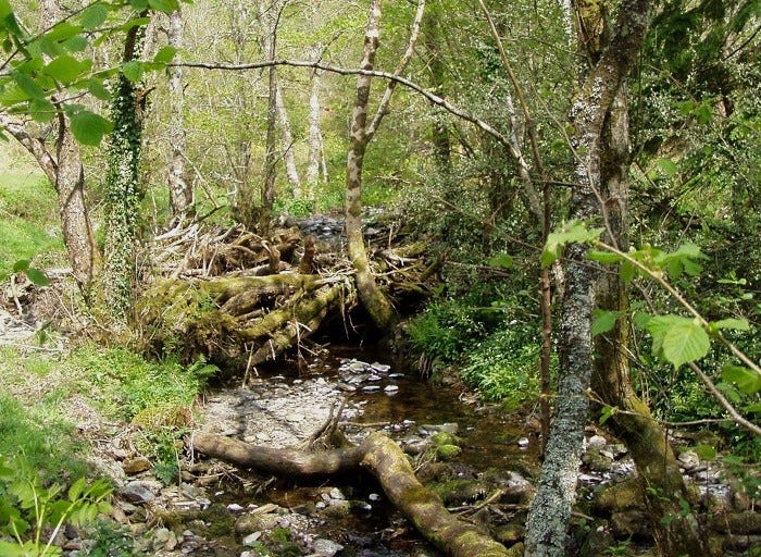
Interestingly, after the Great Flood of 2001, many trees that were torn form the banks ended up stuck in the narrow gorges of the Las and Wen. These formed natural dams and interrupted the flow of gravel. Given time they fill up with debris and its easy to imagine and over time, a river left to evolve naturally will gradually raise its bed. Its easy to imagine adapting this as a technique in designing for restricting the down stream flow of materials in such river systems. However, in the interests of tidiness, all such blockages were removed by Forestry Commission Cymru, allowing the gravel trains to continue without hindrance.
above: a natural dam on one of the tributaries of the Mawddach, the Afon Las (the Blue River, also known as the Afon Babi, the River of the Baby, which is another story and a good one…). Here, the water behind the dam is raised by about 4 feet, 1.2 metre. Many of these, repeated along the course of the rivers, could buffer the effects of high rainfall, holding more water in the river system and releasing it more gradually. However, a traditional urge for tidiness means they get removed, allowing the gravel to continue its journey downstream.
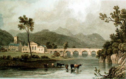
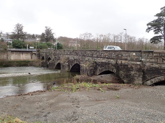
These gravel train rivers carry vast amounts of material downstream causing considerable problems. Heavy machinery is required to clear debris regularly from the arches of Bont Fawr (Big Bridge) in Dolgellau and the mouth of the estuary at Abermaw, (Barmouth) is continually silting up. Graham managed to find an old painting of Dolgellau showing Bont Fawr and its informative to compare the height of the arches to a contemporary photograph.
above: old painting of Bont Fawr (Big Bridge) in Dolgellau. Note the height of the pillars supporting the arches.
above: Bont Fawr as it is today. Enough said!
As global warming ramps up, water management is going to become absolutely critical and its vital that we understand as much as we can about the natural movement of water through systems. There's a huge amount to learn here including naturally occurring features that can be readily adopted into designed systems, if we are prepared to learn from nature and work with her.
Thanks for reading. There’s more to come on Forest Hydrology at some point. A warm welcome to all new subscribers! Please feel free to comment, make suggestions or even requests for areas to cover. Delays in the newsletter have been due to a combination of internet outages (coincidentally (?), one at the peak of the recent huge solar flare) plus good weather, allowing me to catch up on winter fuel and fill up the garden, as well as all the usual and unusual challenges of living a more or less compromised life in a struggling society. So no change there then. Till next time, hwyl! Chris.
In my head I remember something like 4 to 40 acres for a mature oak tree but I have been unable to verify this or indeed find any data on total surface area of tree leaves/needles. If anyone has a reference for that sort of information, please let me know- Thanks.
His Forest Hydrology master work has a fully indexed web page as a front end with links to downloadable pdf sections. It’s a really thorough look at forest hydrology related to a specific forest, namely Coed Y Brenin. For any one interested in forests and water flows its well worth dipping into. The section on the upland blanket bog, for example, is really good and widely applicable.
Graham's web site has links to a range of interesting research, including Mechanisms of Flooding in the Mawddach Estuary.
Epicentre is a much maligned term. Originally it refers to the point on the surface of the earth directly above the centre of an earthquake. It is also used to refer to the point on the surface of the earth directly below the centre of an air burst nuclear explosion. It seems to have been mistaken to mean something like the very, very centre or the extreme centre of more or less anything and is used incorrectly in a whole host of inappropriate contexts. A centre is a centre- it can't be more of a centre or a super centre or whatever. So I think I am using it correctly , to indicate the point on the earth directly below the centre of highest rainfall but I could be wrong...end of minor rant.
I sent details of the fascine causeway design to all the relevant bodies and agencies in the 1990s without getting a single reply. I was then quite excited to learn that a bog reclamation project on Pumlumon was using fascines. When I checked out the details I found that rather than using the fascines to create causeways on contours across the flow, blocking drainage ditches along the route, at Pumlumon they had placed dozens of fascines all the way along the ditches. This is completely unnecessary as a single fascine can block a ditch and the ditch silts up upstream without any further effort.
They also used mini-diggers to position the fascines which again seems completely unnecessary. Apart from using fossil fuels, any sort of machines operating in bogs will cause compression and damage. By using the causeway technique and starting from an edge, you create your dry(er) walkway as you go.
Interestingly (again, in the Chinese sense) Cockermouth in Cumbria experienced a much more severe flash flood in the same season with the same rate of rainfall but persisting for fourteen hours, causing enormous damage and loss of life.




Great to read Chris, some images a recall from lectures yo have been giving over the decades, mxed with newer thoughts and observations.
Very interesting. When I've seen wispy clouds over forest like that I've always thought it was clouds clearing away that had been 'caught' somehow in the woodland. It reminds me of when I was 15 and I went camping for the very first time with the Guides on a hill near Rowen. We had to sleep with our tent flaps open and I have an abiding memory of waking up and looking straight along the Conwy Valley and seeing little wisps of cloud 'caught' in the woods above Dolgarrog. On a side note I also looked down and saw a little lane snaking up a hill opposite little thinking that I'd end up living up that hill many years later! It's no longer possible to see the lane from where I camped because there are too many trees.