Last time I looked at the current state of play in Coed Y Brenin, emphasising how the Forestry Commission's “do nothing” approach had led to a volatile situation with unmanaged, grossly overstocked stands of over-tall trees with very limited root space, prone to fire and wind-throw. I'll continue here, dealing first with fire.
above: Betws Y Coed fire- picture from The Independent
Foresters distinguish between two types of fire, namely ground fire and crown fire.
Ground fire, as the name implies, is a fire that is confined to the ground. Forest floors will vary according to management; in well thinned larch plantations, for example, there may well be grasses below the trees. Otherwise we are likely to find moss on needles or just needles. Given increasingly hot summers, these floors are liable to dry out- in 2022, with temperatures at a record (for us) of 35°C and humidity down to 30% (extremely low for so-called “wet Wales”) the floor was tinder dry.
Given a source of ignition (carelessness, broken glass concentrating light, lightning strike) a ground fire can start and with sufficient wind, can move extremely rapidly (faster than you can walk). However, generally, provided there is no other source of fuel available, the fire will burn fast but not hot and trees may survive. With such a fire there is a good chance that it can be controlled by firefighters on the ground, working with beaters, pumps and hoses (if there is a convenient water source), shovels and the like. Tracks and rivers can form barriers that the fire cannot cross and there is also the option to create fire-breaks to halt the spread.
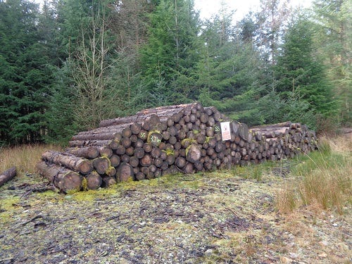
However, if there are fuels available other than grass, needles and moss, such as branches, fallen trees, old log piles and the like, then the fire may become more established and burn hotter and slower.
above: eight year old stack. No one seems to want the wood…
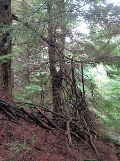
The greater danger is if the fire manages to get up into the upper branches and crowns of the trees where there is a considerable potential fuel and plenty of exposure to air (oxygen). Stands in the thicket stage are most prone to this with shaded out, dead side branches down to the ground but it can also be achieved by leaving dead wood or other debris hanging up against other trees. In either case, the debris or branches form a ladder up which the fire can ascend into the crowns.
above: fire ladder
Once in the crown the fire is impossible to extinguish from the ground and the only methods involve helicopters or other aircraft dropping water from above. Due to the greater amount of fuel, the fire burns extremely hot and is almost totally destructive of trees and most other life, not to mention any buildings that might be in the way.
The move into the canopy is even easier for the fire if the forest is on a steep hillside and the source of ignition low down on the slope. Such a crown fire can move up hill with appalling speed, creating its own wind as superheated air rushes up slope, often carrying burning debris with it, meaning the fire can spread very rapidly to other, more distant areas, over-leaping tracks, rivers and fire breaks. As I've mentioned before, Coed Y Brenin abounds in Elltydd, steep wooded hillsides.
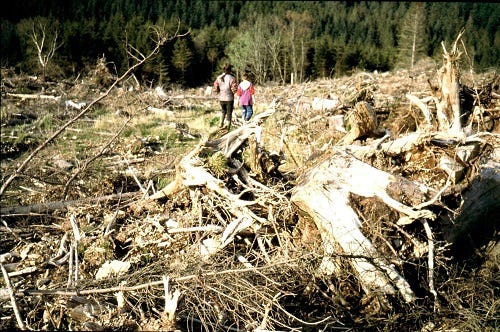
Back in the 1980s, very much aware of the expanse of clear-felled land to the north of our property, and conscious of the large quantities of up-rooted stumps, branches and even timber left there after the clear-felling and pit digging, I spoke to older foresters of my concerns. They were dismissive; fire in clear-fell tends to just go out, I was told, it doesn't spread. Fires in thickets were their only concern and as most of Coed Y Brenin had, by that time, long passed the thicket stage, the risk of fire, in their eyes, had largely receded.
above: 1980s clear fell on Mynydd Penrhos
In the 1980s my weather diaries record almost continuous waves of rain coming in from the west, every 3-5 days and lasting 2-3 days. There might be several weeks of cold, hard frost over winter when a high settled over the country and a surprising two week window of dry weather that floated about sometime during the spring. Apart from that, regular rain was the norm and hence the perpetual high humidity that made the Mawddach Estuary's hills renowned in Europe for their lichens, liverworts and mosses.
Roll forward thirty years or so and we have a very different situation, a stark example of the climate change wrought by global warming, a consequence of our ruthless exploitation of our planets resources and in particular, the extravagant burning of fossil fuels. Now, it is not unusual to go for weeks or even several months without significant rain, usually in the spring and early summer. In the last few years we have also experienced dry, late summers
I have for some time used a simple 30,30,30 guide to fire risk that I picked up from Californian firefighters (off the radio, not a visit!). That is, the fire risk becomes extremely high as the temperature reaches 30°C or above, humidity sinks to 30% or lower and wind-speed hits 30 mph or above.
The 30°C is easily beaten these days, though it took a while for us to hit it here. Being in a forest and a (once) high rainfall area, the humidity felt pretty safe as I'd never see it drop below about 45% but now all this has changed.
During 2020, though I have no method of measuring wind speed other than my own senses and observations, with an exceptionally dry late winter and hot and dry early spring, I watched these two measurements, temperature and humidity, converge each day towards 30 until one morning in late April, with a fresh breeze stirring branches, I said to Lyn that conditions were ideal for a fire.
Setting off for a wander in the afternoon I had not gone far when I suddenly realised I could smell burning wood and taking a look behind me I saw our little hanging valley filling with smoke. My first thought, as I ran back, was that it was our house but on nearing it became clear that the source was elsewhere. There followed an hour or so of fruitless trotting back and forth and round about; who would have thought a forest fire could be so hard to find! The smoke continued to drift about but the direction seemed to change continuously, a consequence of the complex faulting and deep valleys of Mynydd Penrhos. Even the coming of dark, when you might have thought a glow behind a hill would have given a clue, revealed nothing.
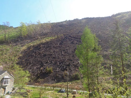
above: Afon Wen fire site, April 2020 after extremely hot, dry early spring
It wasn't until the next morning that I actually found the fire, or where it had been, only a quarter of a mile away as the crow flies (400 metres) but separated from us by the Afon Wen fault and river, a 500 foot deep, (about 160 metres), extremely steep divide . The smoke had blown down the fault line and then back up to our hanging valley.
The fire had been started accidentally by a local using an angle grinder to cut off a metal gatepost and not looking where the inevitable shower of sparks was going. These had crossed the road behind him and ignited tinder dry grasses on the opposite verge from which the flames had spread into debris left after clear felling at the bottom of the east side of the valley.
The fire must have burnt in a spectacular fashion, racing up the steep valley side through the debris of the clear-fell in an ever widening V till it got to the top, met the east wind which, very fortunately, was just strong enough to stop it getting any further but not strong enough to carry burning material across the valley, from where it could easily have spread into the Core Block. The fire site was still being patrolled by firefighters as flames re-started here and there on the hillside.
In 2022 we were fortunate in that, though temperatures were higher still, we had small amounts of rain at just the right intervals to keep the humidity a little higher. However, there was a serious fire near Betws Y Coed, some 30 miles to the North, which burned for several days, again, on a steep hillside. This time it was mixed woodland, conifer and hardwood, a disturbing fact. Why?
I remember reading in books on pre-history that described the so called “slash and burn” techniques used by ancient peoples to create clearings for food production or to relocate their villages. This occurred in tropical and semi-tropical climates. Practical archaeologists had tried this in European situations but found deciduous woodland very difficult to burn, even after ring barking the trees and leaving them for a year to die and begin to dry out. How that has changed!
As I mentioned before, as well as fire, the grossly overstocked, unmanaged stands are also very prone to wind-throw. This can be exacerbated following periods of high rainfall, when the soil becomes saturated. As an example I mention the extremely heavy rainfall prior Storm Imogen of February 6th 2016.
above: windthrow in grossly overstocked, unmanaged stand
Its not unusual to record rainfall of 300-400mm a month during the winter here but November of 2015 saw rainfall of 560mm, a record for me, broken immediately the following month when in December I recorded 662mm. January 2016 was still exceptionally high at 440mm meaning that we had had about 1.6 metres of rain in three months when the ten year average for a whole year is 2.3 metres- that's roughly 70% of the annual rainfall.
With such huge quantities of water, the thin soils over bedrock on which much of Coed Y Brenin grows becomes totally saturated and semi fluid. Worse, water can begin to flow between the bedrock and the soil, ideal conditions for landslip as well as wind throw.
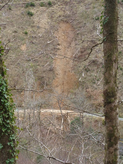
above: minor landslip on a steep, clear-felled slope. The debris has been cleared from the road.
When the great storm hit, the consequences were locally catastrophic with hundreds of trees blown down across Mynydd Penrhos. The eastern valley side of the Afon Wen was particularly badly affected. Here, the Forestry Commission's “do nothing” approach had meant that the conifers on the ridiculously steep valley side, which should probably never have been planted in the first place, had reached heights up to 80 feet (25 metres) and were of considerable girth. Many of these blew over and crashed down the steep slope, bringing down considerable quantities of earth with them but in some places, large landslips also occurred, taking the trees down with the soil with some trees remaining standing!
The result was the road alongside the Afon Wen in the valley bottom was completely blocked and remained so for several years while NRW attempted to remedy the situation by clear felling the slope, not an easy task by any means. Too steep for harvesters to operate on, it was down to people on the ground with chain saws, winches and skylines; dangerous work, with at least two serious accidents, one requiring rescue by helicopter and it was very expensive, several million pounds, far more than the value of the timber.
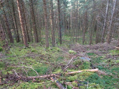
above: harvester track in overstocked, previously unmanaged stand. Note the many thin stems and limited root space.
When NRW finally took over form the Forestry Commission, they did begin to make an attempt to address the previous complete lack of management by starting to thin. However, the necessity to deal with the outbreak of the phytophthora disease (more on this next time) is now consuming pretty much all their time and resources. The attempts at thinning that have been made, while perhaps lessening the fire risk, have not helped reduce the risk of windblow and may even have increased it.
Briefly, traditional thinning was a task undertaken by individuals with chainsaws. First thinnings involved taking out alternate rows of trees after the young trees branches had met, closed the canopy and shaded out the grasses which are the main competitors to trees. The trees then grow upward and outward and the canopy closes again. For second and third thinnings, a forester would usually mark the trees to fell, removing any dead trees that had been shaded out and the smaller or over large trees, aiming for a stand of evenly sized trees.
However, the thinning these days, here in Coed Y Brenin, is done with a harvester. First the machine cuts access tracks at intervals into the forest, then, working from these tracks the harvester reaches into the stands with its cutting arm on either side and cuts out some of the trees, leaving all the timber in lengths to be collected by a forwarder operating along the same tracks.
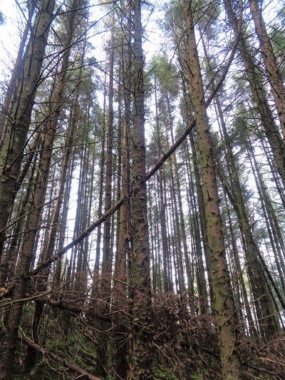
above: the same grossly overstocked, unmanged stand. Note the crowded, thin trunks, small crowns and open canopy. These are more like dwarf conifers on ridiculously tall stems. There’s also wind throw within the stand here.
However, given that these stands have remained in a thicket stage for some 30-35 years, the result is a very open plantation of towering, relatively thin stemmed trees whose roots have been restricted and whose crowns are very small, like dwarf conifers that do not seem to be growing out to fill the new space. Its a very strange feeling, walking in these tall stands with light flooding in, grass and moss growing now where previously it was dark and impenetrable. Where light can flood in, so too can the wind and the consequences are there to see, even deep inside the stands.
Given the likelihood of increasingly severe storms in the future as a result of global warming, it is entirely possible that the majority of the trees on Mynydd Penrhos and indeed Coed Y Brenin itself, may end up flattened in our next hurricane.
I end on that grim thought. Next time I will look at the various plagues which are present here in the forest and already wreaking havoc and following that I will get to how we might get out of this mess. Hang on in here loyal readers, it won't all be negative, honest!
Thanks for reading and please feel free to leave comments!


